The Old Boundary Hidden in a Hedgerow
Learn how to read an old boundary in a hedgerow by tracking its line, checking maps and ground clues, and keeping conclusions cautious.
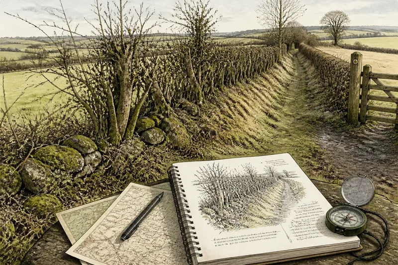
You follow a field edge on a damp morning and notice the hedge dog-legs around a shallow hollow, then straightens towards a lane. An old boundary in a hedgerow can be easy to miss when you look only at the plants; its alignment, banks and gaps may preserve clues to how land was once divided.
Those clues are suggestive, not conclusive. A hedge may mark an older enclosure, a later property line, a practical stock barrier or several changes layered together. A week of careful observation can help you record what is visible, compare it with maps and decide what questions remain open.
Begin with the line, not a story
Choose a short stretch that you can view lawfully from a public footpath, road or permitted access. Do not cross fences or enter private land to inspect it. On your first visit, note where the hedge begins and ends, which way it runs, and whether it is straight, curved, kinked or interrupted.
Use a paper map, an offline mapping app or a notebook sketch to record the course. Mark junctions with tracks, gates, streams and other hedges. A phone compass can help orient a sketch, but treat its reading as approximate near metal fences or buildings. The aim is a useful record, not a precise survey.
Look for relationships between boundaries. Does the hedge continue in the same direction beyond a field entrance? Does it meet another hedge at a square corner, or does one line appear to stop against another? Record the visible arrangement without assigning an age or purpose. These junctions often give you better questions for later comparison than a single stretch viewed in isolation.
Use the week to build a record
Spread the work over several short visits if that suits your routine. The changing light and foliage can make a bank, ditch or gap easier to see on one visit than another. Keep notes tied to a date and viewpoint so you can distinguish a persistent feature from a seasonal impression.
- First visit: Sketch the hedge line and mark its connections, bends and visible breaks.
- Next visit: Look for a raised bank, shallow ditch, stone line or change in ground level beside it. Describe what you can see rather than what you think it means.
- After rain or in low winter growth: Check whether the ground shape becomes clearer. Stay on the path and avoid approaching unstable banks or waterlogged edges.
- Midweek: Compare the line with an older map and a current map, if available. Note where the hedge appears to match a field edge, track or boundary shown on either.
- Final visit: Recheck the same viewpoints and add any gaps, recent cuts or obscured sections. Separate fresh observations from interpretations in your notes.
Photographs can support the sketch. Take one view along the hedge and another across it, including a recognisable public-path feature where possible. Avoid photographing people, homes or private garden interiors. A simple caption such as “bend beside the footpath gate” is more useful later than a string of unlabelled images.
Compare maps without asking them to settle the question
Look at maps from different periods, where local libraries, archives or public mapping services make them available. An older map may show field divisions that have since disappeared; a modern map may reveal which parts remain. Map scales and survey purposes differ, so a line that seems slightly misplaced may reflect how the map was made rather than a change on the ground.
Compare the hedge with the wider pattern. A line that runs across several fields in a consistent direction may be part of a larger boundary arrangement. A short hedge that follows a stream or skirts a slope may instead have been shaped by local terrain or later land use. Neither pattern establishes when the hedge was planted or who set it out.
Keep a two-column note: “seen on the ground” and “shown on maps”. For example, if the hedge bends at a track and an older map also marks a division there, record the match. Do not turn that match into a claim about the boundary’s exact age unless independent local evidence supports it.
Notice what the hedge is made to do
A hedgerow is not just a line of woody plants. It may sit on a bank, beside a ditch, along a wall or at the edge of a track. Each arrangement can help explain the boundary’s practical role. A ditch may carry water or discourage stock; a bank may raise the hedge or mark a division. These features can also be altered, rebuilt or reused, so treat them as clues to function rather than a date stamp.
Look for changes in the hedge’s shape and management: a broad base, a line of mature trees, a close-cut section, or a gap where a gate once stood. They can indicate different treatment along the same boundary. A gap may have been made for access, but it could also be recent damage or maintenance. Record its position and surroundings before suggesting a reason.
Imagine you notice a low bank beneath a hedge that follows a straight line between two lanes. You sketch it, then find that an older local map marks a field division in roughly the same place. The sensible result is a stronger note that the hedge may preserve a former boundary, alongside the unresolved question of when it was formed—not proof of a particular enclosure or owner.
What can the alignment tell you?
Does a straight hedge mean the boundary is recent?
No. Straightness alone does not date a hedge, and old lines can be straight while newer ones may bend around obstacles. Compare its connections and map appearance before drawing even a tentative conclusion.
Can a bank beneath a hedge identify an ancient boundary?
A bank is evidence of a ground feature, not a reliable date by itself. Its shape, relationship to a ditch and fit with other boundaries may help frame an interpretation, but dating needs stronger local evidence.
What if the hedge does not appear on an older map?
That absence may mean the map omitted a small feature, used a different level of detail or showed the land at another stage. Check a second map or local record before treating the omission as evidence that the hedge is new.
When should I ask someone local?
If the line appears in a local history collection, parish archive or land record, ask a librarian, archivist or local history group how that source should be read. Their records may clarify what a map cannot, while still leaving room for uncertainty.
Write a conclusion that leaves room for change
At the end of the week, make a short account with three parts: what you observed, what the maps appear to show, and what remains uncertain. Use language such as “may follow an earlier division” or “aligns with a boundary shown on this map”. Avoid naming a specific owner, date or event unless you have evidence that directly supports it.
That careful wording is useful because hedges change. Plants are laid, cut, removed and replanted; field entrances move; drainage and access reshape their edges. An old line may survive beneath newer work, while a hedge that looks ancient may have been established for a more recent purpose.
When you next pass the same field, compare the hedge’s line with the landscape beyond it: a track continuing across a neighbouring plot, a bank fading at a gate, or a boundary that appears again in another field. Such connections are often more informative than one striking feature. They help you read an old boundary in a hedgerow as a possibility grounded in visible clues, rather than a story the landscape cannot quite prove.